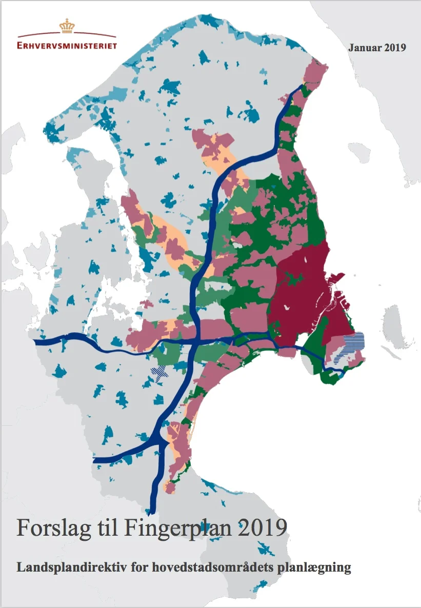
Forslag til Fingerplan 2019 - Landsplandirektiv for hovedstadsområdets planlægning

Suggestion for Finger Plan 2019 - National land directive for the planning of the metropolitan area

the new Finger Plan has a series of maps to illustrate changes to planning in the area around the historic city of Copenhagen


A major revision of the famous Finger Plan of 1947 was initiated in April 2016 and after a period of public consultation - when the 34 municipalities of the capital region were given time to submit comments - a first version of a new plan came into force in June 2017,

Published on 24 January 2019, this is the next stage of that report and there will now be a period for public consultation through to 21 March 2019.

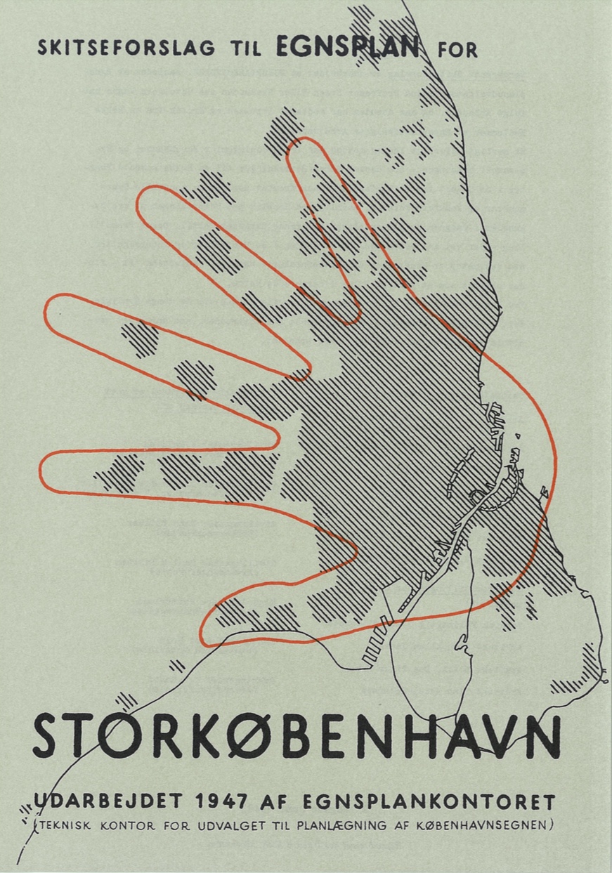
The Finger Plan from 1947 was a key planning report that set the course and controlled the form and the extent of development out from the city through the second half of the 20th century and its influence has continued into this century so it has had a huge impact on the city for more than 70 years.

That plan, to control development, was based primarily on existing lines of the suburban railway that radiate out from the centre of the historic city and new development has been centred on railway stations but with a web of green open space between the fingers … protected countryside that has been crucial as space for nature and for recreation that has stopped the expansion of the city from becoming a solid urban block like London or becoming a sprawl of unregulated development.

The new plan is setting out how to allow for but control further expansion of the city and the region through to 2030 and beyond and it will focus on problems caused by climate change that makes green space and the control of surface water and flooding from the sea increasingly more important. Protection of green land is seen now to be a balancing act and new proposals will be controversial as some green areas could be lost - for instance where they are compromised by being close to major transport links - but there appears to be a commitment to add new areas of protected green space and particularly where this has a clear role in enhancing recreational use.

In 1947, the original Finger Plan, set out the principle that development should be along the suburban rail lines with large buildings, such as city halls and shopping centres, close to the railway stations but the new plan will give the municipalities more freedom to plan for larger commercial buildings with some users up to 1000 meters from the stations in the towns of Helsingør, Hillerød, Frederikssund, Roskilde, Køge and Høje-Taastrup.

Three special areas are designated in Nærum, Kvistgård and Vallensbæk, where it will be possible to plan for larger commercial buildings with many users.

Planners and politicians want to strengthen secondary retail development in the metropolitan area with enhanced areas for local retail in Hillerød, Ishøj, Lyngby and Ballerup along with development in Helsingør and a new town center in Kokkedal.

The report includes proposals for major developments on new land that will be claimed from the sea with Lynette Holmen, a new artificial or man-made island across the entrance to the harbour - where there will be housing for 35,000 but also the island will be part of major coastal defences to protect the inner city from flooding if there are storm surges in the sound. South of the city, Avedøre Holme will be a group of new islands that, primarily, will be for major industrial development. It has been suggested that these developments will bring 42,000 new jobs to the city.

Under consideration is a section of new motorway around the city with the construction of what is called Ring 5 north from Køge, to follow a route between Copenhagen and Roskilde. Presumably, this is connected to assumptions that new traffic will be generated when the road and rail tunnel between Germany and Denmark is built. That international link was given final approval by the German region in December and could be open by 2035. An outer motorway west of the centre would be important for the region because it is possible that by the middle of the century a new major engineering project could be justified so building a bridge or tunnel link between Helsingør and Helsinborg in Sweden that would create a Hamburg-Copenhagen-Stockholm axis with the German and Swedish cities just 500 miles or 800 kilometres apart and with Copenhagen and Malmö at the centre point.


The text of the new plan is set out as major bullet points simply because this is a document for the next stage of consultation but, even at this stage, it is worth reading because local citizens should see this as one way, at the very least, of understanding how their city could develop over the next decade and, of course, like the original Finger Plan, it will set the framework for life in the city and for the built environment of the city through to the middle of the century and probably for a much longer time frame. What the report does have, even in this version, is attractive and informative graphics with a series of maps that make the hard data and the stark proposals easier to see in terms of specific areas and their potential extent and their impact on the landscape.


Fingerplanen / the Finger Plan at 70


Many articles have been written about the Finger Plan. This book from the Danish Architecture Centre in Copenhagen published in 2012 looks at some of the important housing that was built in the 1950s along each of the fingers

There is a major anniversary for the city this year because the famous Fingerplanen - a planning framework for the city by Steen Eiler Rasmussen and Christian Erhardt Bredsdorff - was published in 1947.

It accepted that following the war, and for clear economic reasons, there would have to be not just rebuilding and regeneration in the city itself but also extensive growth outwards and there was a determination to control unplanned suburban spread.

So the Finger Plan recognised that although people wanted to move out of the overcrowded city they would have to travel back into the city either for work or for shopping and leisure and so it took, as a starting point, existing lines of a suburban railway system - the electric S-trains - that ran out from the city. *

By restricting the sites allocated to new housing as broad but clearly defined lines, there would be areas of countryside left between the new municipalities that could be used for agriculture and for leisure or recreation and the plan proposed that some large areas could be planted with trees for new woods and forests.

The plan has served the city well and now covers 34 municipalities with over 2 million people living within the area and the new buildings constructed through the 1950s and 1960s and onwards included housing, municipal shopping centres, new schools, new city halls for local government and new factories.

In part the plan reflected clear social change after the war and new expectations for ordinary working families with the attraction of being able to live in a brand new home and to have not only a small garden but easy access to open space. So it was not just the anticipation that the population of the city would increase but It was in part a reaction to life in the old and often dark and overcrowded apartment buildings in the city itself - small apartments that had relatively poor provision of toilets and bathrooms and rarely had private laundry facilities and certainly most of the older blocks in working-class areas did not have lifts. So, at the core of the plan, was the need to build better housing for more people.

But the Finger Plan is seventy years old so not only have the ways that people want to live changed, but the plan did not and could not have anticipated the changes in the city and the developments of the late 20th century and in the last seventeen years of this century. 

Even in Copenhagen, despite the obsession with bikes, there was still a phenomenal growth in the private ownership of cars through the 1960s and 1970s and an increase in the number of not just longer commutes to work but, for the first time, extensive leisure traffic - so the idea of a trip out to the coast or to a museum or gallery by car, rather than by train or pleasure boat, and along with that the growth of tourism - so not just people wanting to drive into Copenhagen itself but car journeys to the increasingly busy airport or journeys from some distance away through or around Copenhagen en route to southern Sweden via the new bridge to Malmö and that was certainly not anticipated in the plan. So now, as well as the suburban rail lines, there are major motorways running into and around the city that have stimulated developments outside the inner city.

Nor could the plan have anticipated the extent of development on Amager to the south of the city, so really outside the Finger Plan, or the changes in the inner harbour area as the commercial port and the naval base in Copenhagen moved out in the 1990s and made available huge amounts of land along the harbour for redevelopment where there was no suburban train service or at best odd links.

There has also been a distinct change in the way that people now live in the centre of the city itself or rather a change in both the housing stock and a change in the patterns of family life with more people living alone and more couples starting a family later so needing a different type of home for the first years as an independent adult. 

Developments in insulation, improvements in window glazing - with double and triple glass units - modern materials and much-improved designs for heating and plumbing and sanitation, along with changes in ownership patterns, have all meant that an apartment in an older building can be improved immeasurably and with clearing out of buildings in courtyards, to form attractive communal space, and with new city parks and new city schools of the highest standard then, if young families are staying in the city centre so the movement out along the fingers has been reversed.

In the 1950s the availability of relatively cheap private vehicles and improvements to public transport meant people could move out further and further from the centre of the city but in the first decades of this century, massive improvements in housing in the city has meant people can live close to the centre and now, for many, the ideal is to live without cars or to use public transport as much as possible.

The next major stage in the development of the city could be the construction of new outer flood defences to the east and south with the possibility that more land will be claimed from the sea for housing and so on as at Nordhavn. This would all be in the opposite direction to the finger plan that was primarily to the north and west of the old city.

And the extension of the metro, with both a new inner ring and then new lines out to the south west and to the north east, will create new patterns of commuting that will overlay the radial form of the suburban train system. 

If plans for a second road bridge over the Øresund between Denmark and Sweden - between Helsingør and Helsingborg - is constructed then the possibility of a greater Copenhagen region, including Malmö and its hinterland, could be back on the agenda. At the very least the airport at Kastrup has grown beyond anything that could have been anticipated in 1947 and that gives it a regional role and puts demands on the transport and infrastructure of the area that takes the planning of the city, for the next seventy years, well beyond the shape of a hand with fingers spread out. 


* The S-train system dates from 1934