TOUR OF CPH - Sunday 2 July 2023
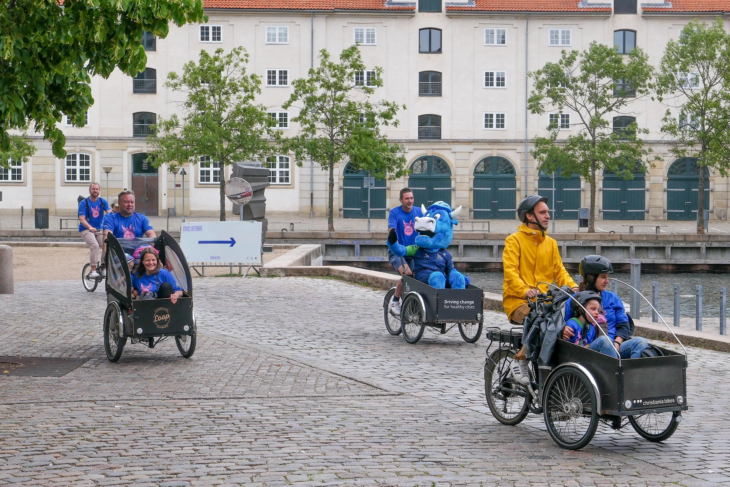
On 2 July 2023 - to coincide with the opening of the world architecture congress in the city - a car-free cycle route was established around the centre of the city with a major cycle event for families - for any citizens as well as any tourists who could rent or borrow a bike - as long as they were on two or three wheels.

The ride covered about 8 kilometres in all through the streets of the old city and with twenty stopping places at key historic sites and major buildings where there were panels with QR codes for information.

The route took cyclists first from the Danish Architecture Center over Lille Langebro and along the quay, on the Amager side of the harbour, before riding through Christianshavn and then up to Holmen and close to the opera house.

Heading back along the canal past the Arsenal, they crossed back to the centre over the Inner Harbour Bridge to Nyhavn and then out towards Tolbod before heading across to the King’s Garden and then down through some of the busiest shopping streets in the city to Gammel Strand and around Frederiks kanal and so back to the Architecture Center.

There was an app for route.

All cars and all other motor vehicles were barred from the whole route with just five crossing points, with barriers and marshals, where some locals in their cars were allowed in and out but the only point where there was free and open access for vehicles to enter the central area was at Knippelsbro where vehicles could cross the bridge from Amager to the centre because bikes on the route were under the bridge on the quay.

Cyclists could join and leave the route at any point but there was an official start and finish at the Danish Architecture Centre where there was a festival area on Bryghuspladsen - in front of BLOX - with activities divided into four themes ……..

Green Everything - food, urban gardens and Hello Kitchen
Splash Splash - Green Kayak rubbish collection + fishing in the harbour
Active City - street sports, dancing and Parkour
Game’ on Move it - gaming, exercise + working out

TOUR OF CPH
Sunday 2 July 2023
12 to 15pm


I’m not sure if this event was as well as or instead of the annual Car Free Sunday.
If a date and a list of roads to be closed is published later in the summer, I will post infrmation on the blog

car free Sunday September 2021

Many of the cyclists were wearing T shirts with the motto Driving Change for Healthy Cities …. a campaign supported by Novo Nordisk that continues on from a similar cycle ride last year when the barriers for the opening section of the Tour de France last year were kept in place for a second day so that cyclists in the city could try the route

In the city, bike jams are surprisingly common.
OK …. not that surprising when you think about the number of bikes here.
But it’s usually at busy road junctions in the morning or in the evening when cyclists are commuting between home and work ….. here it was simply a hard turn to the left and then immediately a turn to the right to ride down to the canal in Christianshavn that slowed down the cyclists on the Tour.


Inderhavnsbroen / the inner harbour bridge

Inderhavnsbroen - the inner harbour bridge for pedestrians and bikes that crosses from Nyhavn to Christianshavn - opened in the summer of 2016.

It provides an important and fast link between the old city, on the west side of the harbour, and Christianshavn, Christiania, Holmen and the opera house on the east side of the harbour.

Until the completion of the bridge, the simple way to cross the harbour was to use the ferry between the Skuespilhuset - the National Theatre - and the opera house - a distance of about 600 metres door to door by foot and boat.

To walk or to ride a bike from the theatre to the opera house without using the ferry meant going down to Knippelsbro and then back up to Holmen - a distance of just over 3 kilometres.

With the Inner Harbour Bridge and the new three-way Transgravsbroen, it is still 1,500 metres from the door of the theatre to the door of the opera house.

By car it was even further. When I first moved to Copenhagen, cars could not drive over the bridge from Christianshavn to Holmen so the route meant driving over to Amager and then across the north side Kløvermarken and up to the causeway at Minebådsgraven and from there to Holmen and the Opera House ..... a distance of well over 6 kilometres.

Inderhavnsbroen was designed by the English engineers Flint & Neill who are now a subsidiary of the Danish engineering group COWI.

It has been nicknamed the Kissing Bridge because of the unusual way that it opens and closes to let large ships move up and down the harbour.

read more

Inderhavnsbroen from the south …. Havngade and then Nyhavn are to the left and on the right is Nordatlantens Brygge - the warehouse on the east or Christianshavn side of the harbour
the cranes are for new apartment buildings on Papirøen


the bridge from the east or Christianshavn side looking up Nyhavn towards Kongens Nytorv

the bridge from the east with Nyhavn beyond with the centre sections open for a ship to come through


Copenhagen by bike

There is a new section of the web site … copenhagen by bike.

Because it’s January, I was doing some basic tidying up and general housekeeping for the blog, and I realised how many posts there have been here about bikes and about biking in the city.

Most of these posts have focused on planning issues - on new bridges for new cycle routes or new street layouts - but it is probably useful to pull all these together in one place so, over the coming weeks, old posts will be copied across to this new and separate section.

Recently, I came across this amazing photograph. It appears to date from the early 20th century and shows a man with a bike, out on the frozen harbour, with the triangular fort in the background. For me, it sums up the Copenhagen attitude to having a bike. Basically, there should be nowhere in the city where you can’t cycle.

And you certainly can’t accuse people here of being just fair-weather cyclists.

copenhagen by bike

cycle city Copenhagen

It has been said many times and in many places that there are a lot of bikes in Copenhagen but, even so, it's worth repeating because there really is an amazing number of bikes in the city.

Certainly more bikes than there are cars but the statistics actually show that there are more bikes than people ... approximately five bikes for every four people.

Four out of ten Danes own a car but nine out of ten Danes own a bike and, in Copenhagen, around half of all journeys to work or to school or college are by bicycle.

Bikes first appeared on roads in the city in the late 19th century and by the 1920s and 1930s bikes had become a common and popular form of transport for ordinary people.

The city is relatively flat and, even now, Copenhagen is relatively compact so it is about 15 kilometres (or 9 miles) from Charlottenlund, in the north, to Ørestad or Kastrup on Amager in the south and 13 kilometres (or 8 miles) from Brøndby on the old western defences of the city to the beach on the Sound on the east side of Copenhagen.

Children here learn to ride a bike when they are very, very young and many, from the age of seven, cycle to school alone. Teenagers, with several friends, are happy to pile onto a cargo bike to head out for the evening and everyday you see parents on bikes taking very small kids to nursery school or picking up a bike basket of food at the local shop. As many elderly people continue to use bicycles, they are clearly the popular choice for easy and cheap transport across all age groups.

Bikes are not just used for practical everyday trips but at weekends you see whole families or large groups of friends heading out on trips and racing clubs and bike events, like triathlons, are incredibly popular both with participants but also with large crowds of spectators.

In the inner city, with its narrow cobbled streets, bikes can certainly be quicker and easier than using a car and if you think that finding a bike rack is a hassle then try to find a place to park a car.

If you live in an inner-city apartment building then finding on-street parking for a car is almost impossible but most courtyards have bike racks and, if push comes to shove, or if you have a much cherished and very expensive bike, then carrying the bike up into your entrance hall or up and out onto a balcony, if you have one, is an option.

Each year about 500,000 bikes are bought in Denmark with a population of 5.6 million and I presume most of those are upgrades rather than replacements for bikes that have been lost or stolen although, to be honest, dredging the canals and the harbour for discarded bikes is a well-organised annual event. 

Statistics taken from Cycling Embassy of Denmark
Bicycle statistics from Denmark

Nørrebrogade in the 1950s


the bike lane on Vester Voldgade is well used but here, on this particular day, slightly less frantic than Nørrebrogade

this is the route from Lille Langebro, the new bike and pedestrian bridge over the harbour, to Rådhuspladsen - the City Hall and the square in front of the city hall

Lille Langebro


Københavnerkortet / The Copenhagen Map

What makes cycling in the city easy and popular is the infrastructure for bikes ... that's the network of designated bike lanes along roads - to separate cyclists from other traffic - that makes being on a bike as safe as possible and there are also green bike lanes, with bikes segregated from vehicles, that make riding a bike fast, safe and a pleasure.

The first bike lane was laid out along Esplanaden, below the citadel, in 1892 so, this year, that's an astounding 130 years ago.

But, of course, there is also a win-win situation for cyclists where the more bikes that there are in the city then the more bike shops and bike repair shops there are and the more enthusiasts and the more bike makers there are and the more chance there is to find exactly the right bike for you.

Perhaps, the only serious problem for cyclists in the city is finding somewhere to leave a bike while you are at work or shopping or when you're out for the evening.

For people commuting every day, cyclists who have lived much of their lives or all their lives in the city, they know exactly where they are going and how they are getting there. That is why cyclists here move fast and get frustrated with tourists or pedestrians who drift around on bike lanes or dither and saunter across at pedestrian crossings .... but, even if you know the city well, keeping track of new bike lanes or plotting a route out to a new place can be a bit of a problem.

I have been meaning to post about Københavnerkortet - The Copenhagen Map - that is an amazing on-line resource.

It's a dynamic map site that is great for planning analysis but you can select features such as bike lanes with bike parking and zoom in or out and turn and save jpg images or even print out maps. It's a great way to understand an area that is new to you or to plan a bike trip out.

Københavnerkortet


bike racks at Nørreport on the north edge of the historic centre … a major transport interchange with local buses, a metro station and the busiest train station in the country with suburban and inter-city trains


cycle routes across the city with “existing bike path” in maroon and planned bike paths dotted

A “Green Bicycle Route” is marked in green, appropriately, and you can also find the location of racks for City Bikes - the rental bikes - and find bike racks

bike lanes are getting wider .... they are generally 2.3 metres wide, so two people can ride side by side, but the most recent lanes in Copenhagen have set a new standard being 2.8 metres wide which means that a fast-moving cyclist can get past a cargo bike or two cyclists side by side without moving out into car traffic.

it has been shown that when a new bicycle lane is constructed, bike traffic on the road increases by between 10% and 20%

cycle lanes around the historic centre with bike racks … with narrow cobbled streets in the centre of the city, there are very few designated bike lanes although recommended routes are marked

coming into the city there are fast bike lanes into the centre from the north east along Store Kongensgade and out of the city along Bredgade, and from the harbour and the south part of the city to the city hall along Vester Voldgade.

new, better, cycle-friendly lanes are being laid out from Nørreport down Nørregade and, further out, recent road works have improved the bike lanes and road markings on Østerbrogade and along the city end of Amagerbrogade

bikes are given priority or separate time intervals for crossing at busy junctions with traffic lights and blue lanes across junctions are used both to mark clear routes for bikes and to warn drivers in cards and vans and lorries of the danger if they are turning across lanes where bikes have priority


a quick dip in the canal?

Unfortunately, bikes do end up in the harbour and every so often someone comes round to hoik them back out.

It looks as if these bikes, on the quay of Frederiksholms Kanal near Stormbroen, have been in the water a bit longer than usual


update April 2022:
Every Spring a team, with a diver, goes round the harbour and the canals in the centre of the city retrieving what has been thrown into the water.
This year, along with 101 bikes, the haul included:

Three electric scooters
Three electric bikes
Eight standard scooters
Seven shopping carts
20 tyres
11 road signs
30 roadblocks
A flower box

Two bins
Seven scaffolding parts
A table
An umbrella
Two ladders
47 chairs
Three trolleys
Two shotguns