a new library for Nørrebro


At the beginning of August a new public library opened in the old tram sheds in Nørrebro.

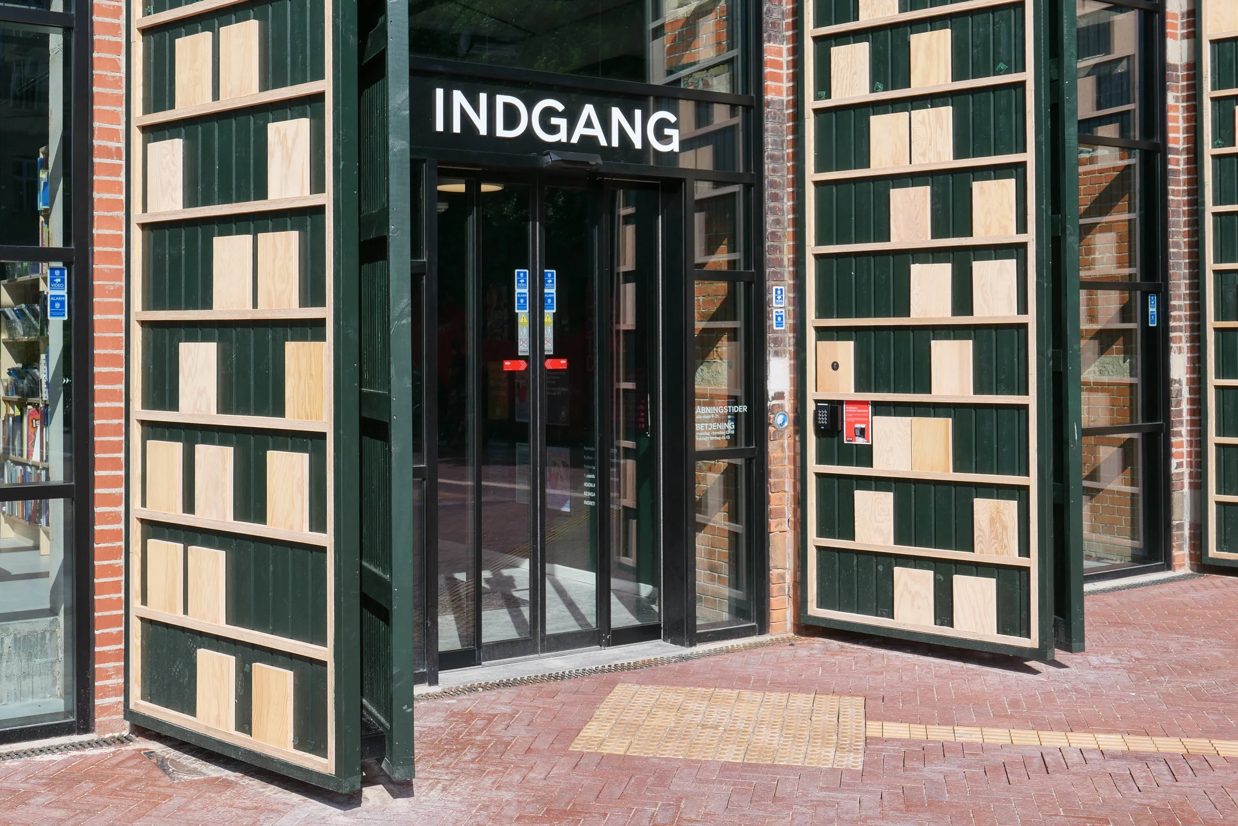
The building is set back from Nørrebrogade with a large square at the front where trams originally turned into the sheds and the original high and narrow openings towards the road have been retained but with new doors that have stylised versions of giant book cases.

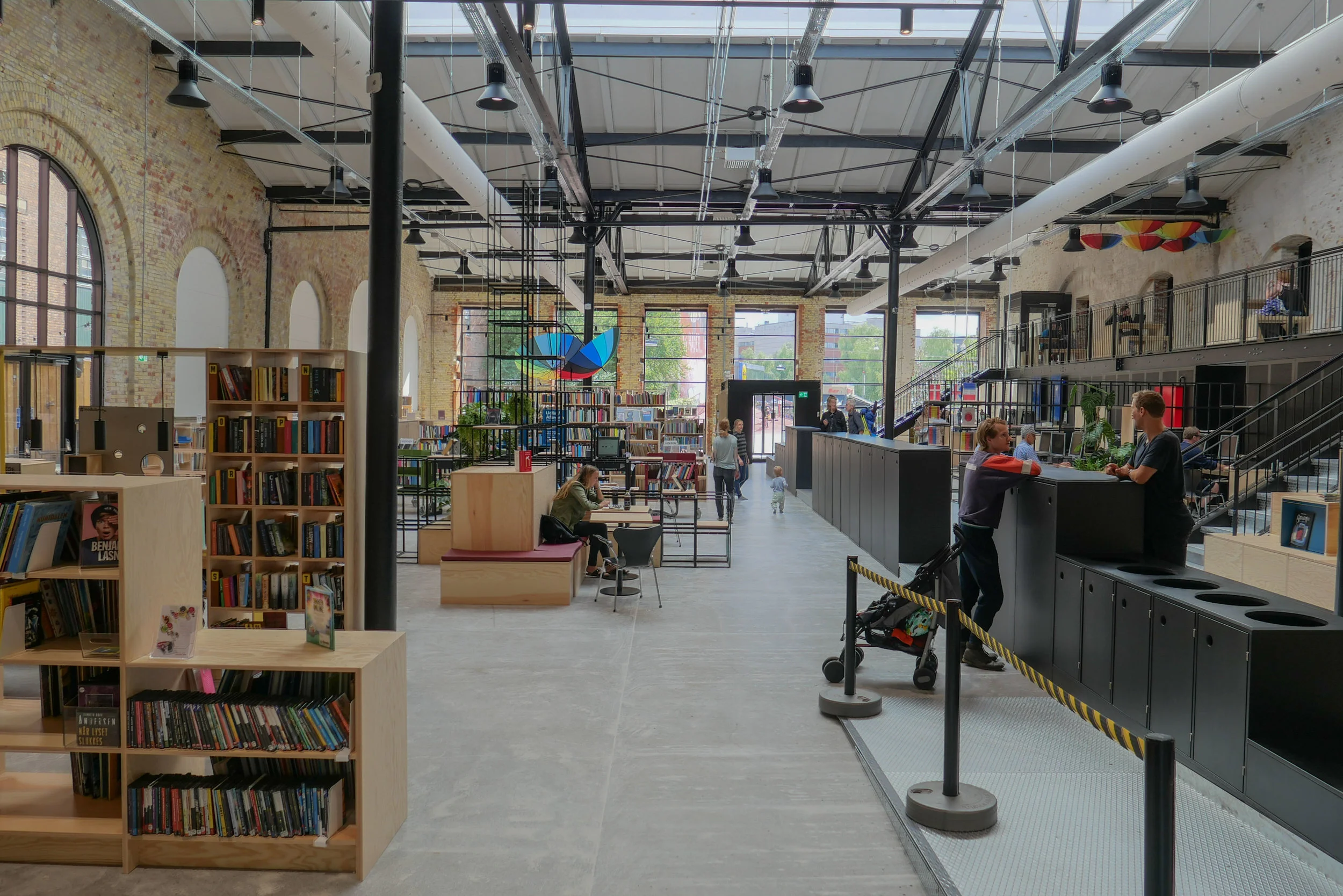
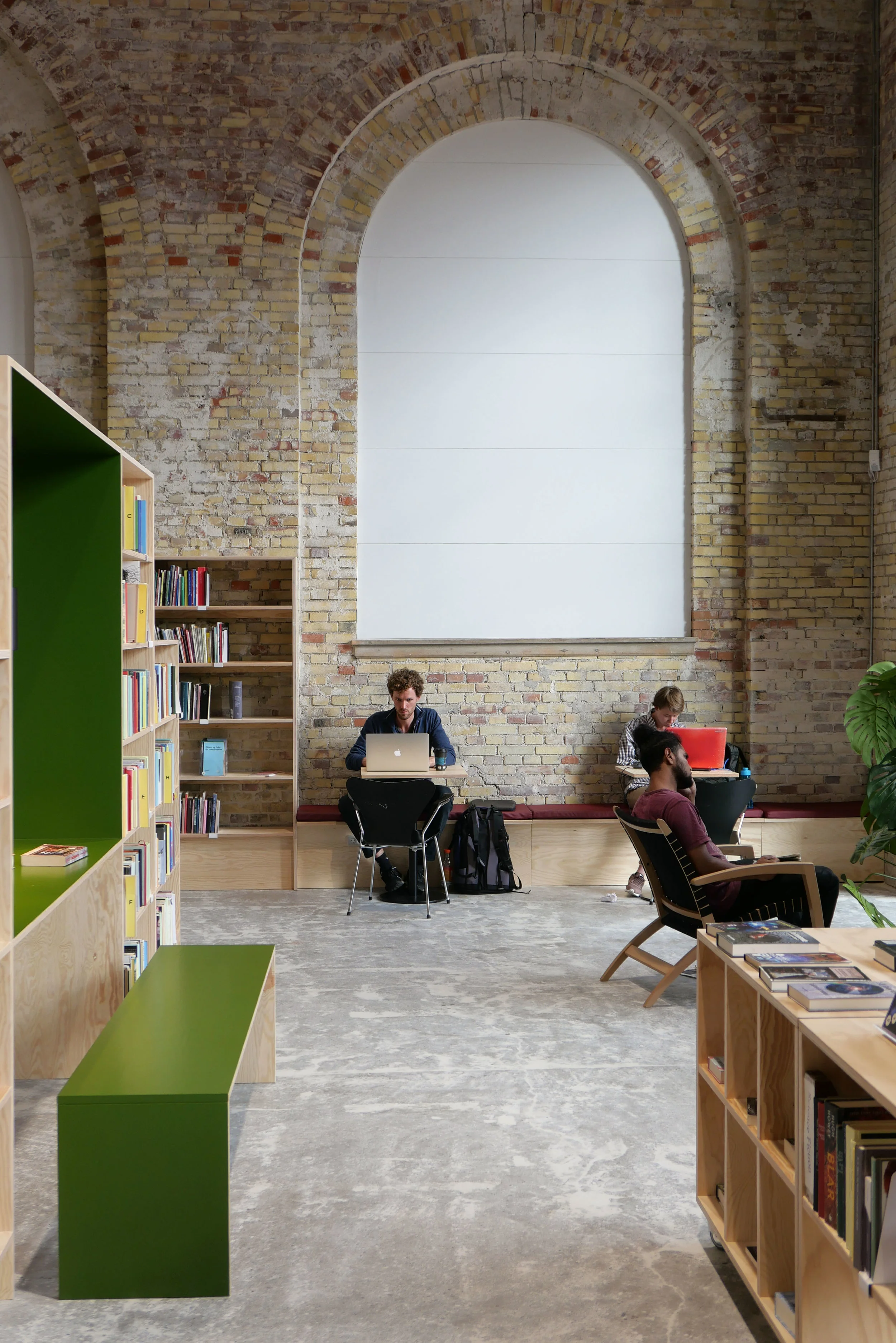
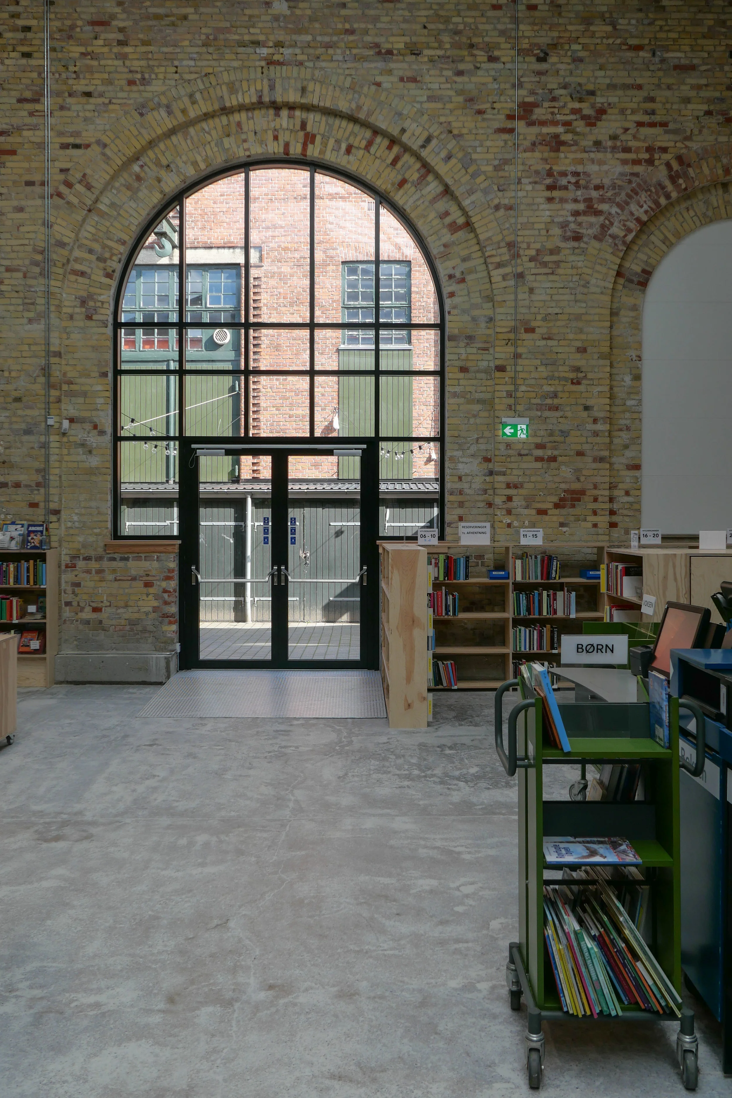
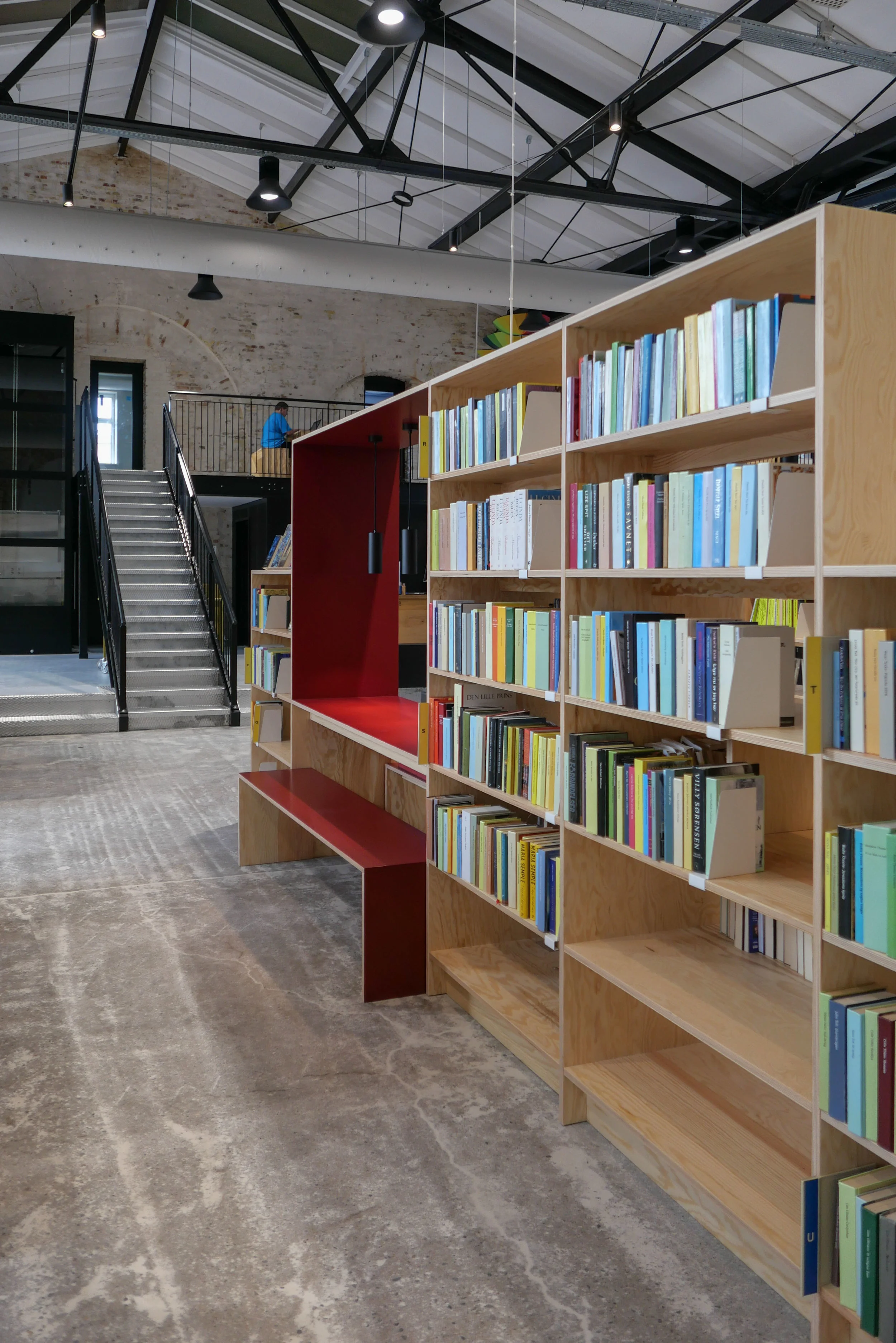
Inside, the single huge space of the shed has been retained with arched openings in the brickwork along the east side towards Bragesgade kept as a strong architectural feature and to flood the space with light. The industrial roof has been kept and is now painted black.

Fittings are in pale plywood and divide up the space and there are integral breaks in the shelving with desk spaces and benches that create quiet places to work but also form views through the space.

Across the west side of the library are smaller spaces on two levels with meeting rooms above for meetings and teaching that the community can use and, like all libraries in the city, there is a play area for children to encourage even the youngest to see the library as a fun place to visit.

Further back from the road is a second huge tram shed and that was converted some years ago to a sports hall - Nørrebrohallen - and there is now a large entrance area and large cafe between the two - between the library and the sports halls - as a place where people can meet.

Running back from the road and along the west side of the buildings is the famous city park - Superkilen - with its outdoor play and sports so this area is now a major hub for the community around. It is anticipated that visitor numbers to the library could soon exceed 1,000 a day.

select any image to open the set of photographs as a slide show

sport and space consultancy KEINGART have published a pdf file on line with plans of the library and cafe area


Enghave Plads

Vesterbro - the part of the city immediately west of the central railway station - is a densely-occupied area of apartment buildings with most dating from around 1900.

This was a strongly working class part of the city with the main rail line forming the southern boundary and with the meat markets, gas works and the harbour presumably supplying much of the work and the Carlsberg brewery was, until a few years ago, to the west.

The street pattern of the district is complicated with two main roads - Istedgade and Sønder Boulevard - running out at an angle from the railway station at the north-east to the south east but with secondary cross streets of traditional apartment buildings running north to south and there are also several streets running across the area from south east to north west so it a complex pattern of a grid but overlaid with a Saint Andrew cross so some streets meet or cross at odd angles.

At the south end of Istedgade is Enghave Plads - a large open square much wider east to west than the distance across from north to south and it narrows at the centre. This square is where several tram routes met so it was always an important point in the area and immediately to the west is a very large square with a major public garden - Enghave Parken - that has large apartment buildings on the north, west and south sides so the two spaces run together though divided by a busy main road - Enghavevej.

Enghave Plads is the site of one of the major new metro stations on the new circle line that will open at the end of September. The east end of the square and some of the surrounding streets have been boarded off for about a decade with major construction work for the metro but the boarding has just been taken down and the space with it's new landscaping opened officially.

There are large areas for leaving bicycles across the north or darker side of the entrance steps to the metro station but across the south side of the metro entrance there are raised beds with Corten edging and long raised bench seats and then to the west more open space for events. This area has striking new seating that has deep red slats on a black metal frame and these form great bold curves though the initial reaction to the seating has been mixed - some asking exactly why people would want to sit next to each other in long rows even if they are curved. Mature trees to the west, along the main road, have been kept and provide a baffle against the sound of traffic and shade for more seating and an area that is fenced for ball games.

Copenhagen Metro

Vesterbro with the main railway line to the south, the MeatPacking district in the cirve of the railway and the main railway station top right
Enghave Plads just left of centre and Enghave Parken towards the left side

Enghave Plads from the east with the square of Enghave Parken beyond

tram leaving the square and heading along Istedgade towards the railway station … the area between the buildings and the central space has been paved over and the main through traffic has been restricted to the north side of the square


smart city data in action …..


The 5C bus route through the city provides one good example of the use of smart data in Copenhagen.

New buses were introduced on this major cross-city route last year. These buses cross the city - passing through the major transport hub at Nørreport, stoping at the central railway station and run out to the airport so it is crucial that passengers have reliable and up-to-date information.

Displays at the bus stop show arrival times for buses approaching the stop - an information service already well established on other bus routes - but once on the bus there are side panels that show the next stop and route maps with information about changing to another bus service whose route intersects. Large overhead displays updates to show clearly, for the next stop, times for buses on other routes and, as the bus approaches the central station, there is not just information about the next available train and the time of departure (updated in real time) but also the number of the platform where the train will depart.

Passengers have access to the same data on their phones if they are planning their route ahead and phones, and for passengers travelling with a rejsekort or travel card, an app on a home computer records trip details for reference but also, of course, this data is available for the efficient management of the system.

With the opening of a new circle line of the metro this year and with plans for a light railway, the system will, more than now, allow passengers to swap between different systems and data systems will make this as easy and as reliable as possible.

Lynetteholmen - a new island across the harbour

Included by ministers in the launch in January of their 52 point Capital Initiative was a major project for a large, new island to be constructed across the entrance to the harbour. Work could start in 2035.

Under a heading Room for Everyone it was, in fact, the first point of the 52 - but already the proposal seems to have generated a fair amount of criticism.

The island, to be called Lynetteholmen, could have housing for at least 35,000 people and eventually work for as many and would include coastal protection measures to stop surges of storm water entering the inner harbour but it would have a fundamental impact on the character of the inner harbour by closing off views out to the sound and would restrict the routes of access into the harbour for large and small vessels.

Although the new cruise ship terminal at Nordhavn is outside the proposed island, the drawing shows further quays for large ships on the seaward side of the new island so it is not clear if these would replace the present berths for cruise ships along Langelinie Kaj.

note:

Politiken published an article on the 3 March with comments from a workshops with architects and engineers and planners where it was suggested that the island, as shown in the drawing first presented by the Prime Minister in October, is too close to the Trekroner fortress and is too large with several critics suggesting that it should be broken down into a series of smaller islands. No further decisions can be made until tests of the sea bed are completed and until related projects are confirmed including the plan for a major road link across the east side of the city that would have to cross the harbour and the proposal for an extension of the metro through a tunnel between Refshaleøen and Nordhavn.

the metro, the bus and the harbour ferry in Copenhagen


With the start of a new year this is clearly a time for new plans and new schemes in the city. On the 24th January, the government launched a reorganisation of public transport in Copenhagen.

Metroselskabet - the company who now control the city Metro - will be combined with Movia who run city bus services and the Havnebuser or harbour ferry service.

The new overarching organisation is to be called Hovestadens Offentlige Transport / Metropolitan Public Transport or HOT for short and will cover the provision of transport across 34 municipalities.

Will HOT replace or at least change the responsibilities of DOT - Din Offentlige Transport / Your Public Transport that was set up in 2014? This was formed by DSB - the operators of regional trains - with Movia and Metroselskabet in order to coordinate strategy and to provide a single access point for passengers who need information about ticketing and times and so on across the system.

The reorganisation appears to be a sensible attempt to coordinate transport across the city and certainly at a sensible time … so before the completion and the opening of the new inner ring of the metro. Metroselskabet was set up by the city and by the port authority and has been organised primarily for the construction work and for the completion and opening of the metro system and not for the ongoing running of the metro system.

However, there has already been criticism - not least from Movia.

Current transport is organised across the region - so across Sjæland - and includes the suburban rail system but at this stage, as far as I can see, the S trains will not be included in the remit of the new body. Some have also been critical because this does not include any new money so seems to be simply about co-ordination and synchronisation and does not tackle capacity or improvements as such with no provision for additional equipment. This is important because the current metro line is running at almost full capacity … good in terms of the economics but not so good for passenger comfort.

To be fair, it may well be better to make further decisions after the new metro line opens this summer because the new line is bound to establish very different travel patterns for people in the city … at the very least it creates important new interchange points for swapping between one mode of transport and another and in the months after the opening will certainly reveal new congestion points in the system.

Metroselskabet
Movia
DOT

note:

Back in June, Movia announced that new harbour ferries will go into service in January 2020. These will be electric - recharging overnight but also topping up batteries at both ends of the route at Refshaleøen and Teglholmen. The new service will run every 30 minutes. As the service carries 425,000 passengers each year, this is an important and - with so many new apartments being built at the south harbour - a significant part of the city transport system.